


Eastbourne is a friendly sea side village just a short drive or ferry ride to Wellington City, the capital and cultural centre of New Zealand. Perfect for all ages with schools, shops, library, medical, dental, many recreation options such as coastal rides and walks, hiking in the hills, beaches, sailing and fishing. Safe for children and suitable for the elderly, it’s perfect for families
(c) 2022 Eastbourne.nz


Featured news item
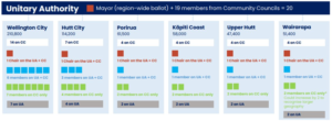 Hutt City mayor releases Head Start discussion documentLower Hutt mayor’s amalgamation plan: A unitary authority and six community councils Justin Wong|Local Democracy Reporting, July 9, 2026 • 4:40pm Ken Laban proposes Wellington and Wairarapa will form a single 20-member authority which will need a super majority to pass its budget and will devolve some powers to local “community councils”. His proposal is not the Wellington region’s final amalgamation plan that needs to be submitted by the Government’s August 9 deadline, but a draft of what […]
 The Eastbourne Herald latest / recent / past delivers the latest local news to more than 5,000 residents of the Eastern Bays of Lower Hutt, Wellington. Email editor@eastbourneherald.co.nz,

 HCC Waste Collection for Monday 10 August
 Bins : BLUE (glass) & RED (landfill)
Options for recycling all other materials are listed here
 Next Lion's Skip Bin is Saturday 29 August
Burdan's Gate 8:00 am to 11:30 am, charges apply, unload help available
 Metservice: Marine Warnings & Watches @ 5:13 am Tue 4 Aug
 Wellington Water recent alerts updated 11:14 pm Thu 25 Jun
25 Jun 11:37 am Water outage notice
Water Outage - Muritai Road, Eastbourne This will affect the following: 446 -521 Muritai Road, both sidesReason for shutdown: Toby Repair
Outage start date: 2026-06-25 11:40:00
Estimated outage end date: 2026-06-25 12:40:00
Properties affected : 25
(To see all outages and other notices go to LAWA)
 HCC Active Consultations updated 12:29 pm Mon 3 Aug
No active consultations.No active consultations.
 GWRC Active Consultations @ 12:00 pm Wed 22 Jul
Kāpiti Flood Hazard Mapping - Engagement on historic flood events
GWRC Active Consultations @ 12:00 pm Wed 22 Jul
Kāpiti Flood Hazard Mapping - Engagement on historic flood eventsGWRC Have Your Say / Consultations
 Bluebridge Service Alerts updated 6:08 am Tue 4 Aug
________________________
Weather alert - Cancelled sailings, Tuesday 3 August and Wednesday 4 August
Updated: Monday 3 August, 3:50pm
A southerly weather system is due to impact Cook Strait Tuesday 3 August and Wednesday 4 August. Due to this weather event the following sailings are cancelled:
Tuesday 4 August
Wellington to Picton: 8:15 am, 1:30 pm, 8:30 pm
Picton to Wellington 7:45 am, 2:00 pm, 7:15 pm
Wednesday 5 August
Wellington to Picton: 2:00 am
Picton to Wellington 2:30 am
All affected customers have been contacted by email and/or text and moved to the next available sailing once it is safe to resume passenger services.
If your new sailing doesnât suit your needs, please contact our team on 0800 844 844 or email bluebridge.bookings@straitnz.co.nz with your booking reference. If you booked via a third-party travel agent and wish to cancel, please contact them directly to request a refund.
We will continue to monitor conditions closely and communicate any further updates to affected customers by text and email. We apologise for the disruptions this has caused to our customers' travel plans. ________________________ Bluebridge fare update due to fuel costs Updated 1:00 pm Thursday 9 April
The ongoing situation in the Middle East continues to drive fuel prices higher. Like all transport operators, Bluebridge has experienced a significant and rapid increase in fuel costs.
While weâve worked hard to absorb these increases, fuel prices have reached a point where we need to adjust our fares to help offset a portion of the additional cost.
Our priority is to keep New Zealand connected with a safe, reliable and affordable Cook Strait service. We recognise the global situation is affecting everyone and we appreciate our customersâ understanding. We hope these conditions are temporary and will continue to review fares regularly in line with changes to fuel prices.
Please note: the new fare levels apply to new bookings, or to amended bookings made after the change on Thursday 9 April 2026. _____________________
East Harbour Parks Status updated 5:18 am Tue 4 Aug
Gollan’s Valley Station
Alerts, Notices and restrictions can be found here Eastbourne callouts updated 6:06 am Tue 4 Aug
No calls reported
Seaview recent callouts updated 6:07 am Tue 4 AugNo calls reported
 RNZ: Latest 5 News Items updated 6:00 am Tue 4 Aug
 Tue 5:40 am Cost blowout puts fees for foreign PhD students under review. Tue 5:13 am Oranga Tamariki office blasted over baby's death also managed Tom Phillips case. Tue 4:33 am MetService warns motorists of snow on roads. Tue 4:33 am Ravensdown's return to profit prompts shareholder rebate as fertiliser prices spike on-farm. Tue 4:33 am No need for Luxon to apologise over Rotorua business meeting comments, mayor says.
  Geonet: recent earthquakes near Eastbourne updated 6:05 am Tue 4 Aug
 2.5 - (weak) 178.5 km NorthEast of Eastbourne at 5:39 am Tue 4 Aug (confirmed)2.6 - (weak) 121.9 km North of Eastbourne at 2:05 am Tue 4 Aug (confirmed)
 1.8 - (unnoticeable) 14.5 km North West of Eastbourne at 9:04 pm Mon 3 Aug (confirmed)
 Product Recalls updated 4:49 am Tue 4 Aug
30 July 2026: ARB Bull Bar Mounting Brackets for MY26 Hilux Bullbar - sold at ARB 4x4 Accessories dealers
27 July 2026: TerraGear Tree Stake Rammer - sold at Advance Landscape Systems
27 July 2026: XTM TTF Fridge Freezer Range sold at Supercheap Auto
22 July 2026: HEAT BOSS Workshop Tripod Electric Infrared Heater 2kw sold via TopmaQ
21 July 2026: Legrand Residual Current Circuit Breaker (safety switch): RX3 RCCB 63A 30mA Type A 2P - sold through trade channels
More products & information on product recalls
